Graissessac
Graissessac is a commune in the Hérault département in the Occitanie region in southern France.

Map
Graissessac | |
|---|---|
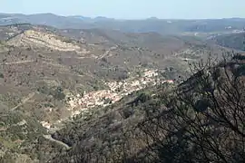 Graissessac seen from the Col du Layrac | |
.svg.png.webp) Coat of arms | |
Location of Graissessac 
| |
 Graissessac  Graissessac | |
| Coordinates: 43°40′54″N 3°05′36″E | |
| Country | France |
| Region | Occitanie |
| Department | Hérault |
| Arrondissement | Béziers |
| Canton | Clermont-l'Hérault |
| Government | |
| • Mayor (2008–2014) | Francine Saisi |
| Area 1 | 10.03 km2 (3.87 sq mi) |
| Population (2017-01-01)[1] | 654 |
| • Density | 65/km2 (170/sq mi) |
| Time zone | UTC+01:00 (CET) |
| • Summer (DST) | UTC+02:00 (CEST) |
| INSEE/Postal code | 34117 /34260 |
| Elevation | 270–1,001 m (886–3,284 ft) (avg. 1,000 m or 3,300 ft) |
| 1 French Land Register data, which excludes lakes, ponds, glaciers > 1 km2 (0.386 sq mi or 247 acres) and river estuaries. | |
Population
| Year | Pop. | ±% |
|---|---|---|
| 1881 | 3,089 | — |
| 1891 | 2,936 | −5.0% |
| 1901 | 2,093 | −28.7% |
| 1911 | 2,042 | −2.4% |
| 1921 | 2,200 | +7.7% |
| 1931 | 2,548 | +15.8% |
| 1936 | 2,416 | −5.2% |
| 1954 | 2,404 | −0.5% |
| 1962 | 1,962 | −18.4% |
| 1968 | 1,510 | −23.0% |
| 1975 | 1,134 | −24.9% |
| 1982 | 924 | −18.5% |
| 1990 | 687 | −25.6% |
| 1999 | 632 | −8.0% |
| 2008 | 690 | +9.2% |
See also
References
- "Populations légales 2017". INSEE. Retrieved 6 January 2020.
| Wikimedia Commons has media related to Graissessac. |
| Authority control |
|
|---|
This article is issued from Wikipedia. The text is licensed under Creative Commons - Attribution - Sharealike. Additional terms may apply for the media files.